NWP System
The goal of Severe Weather Research Center 8-km Numerical Weather Prediction System is to provide experimental meteorological satellite enhanced high resolution nowcasts of the current atmospheric state and short-term regional numerical weather forecasts. The purpose of web-site provided here is to make these satellite data products, and the forecasts produced from them, available for their validation by the US National Weather Service (NWS) and the meteorological research community as needed before their production and use by the NWS on an operational basis for warning the US population of impending High Impact Weather (e.g., tornados, hail, flash floods, tropical storms, and hurricanes).
The nowcast, which is obtained by assimilating PHSnABI soundings together with operational conventional weather observations, provides Significant Tornado Parameter (STP), Most Unstable CAPE (MUCAPE), Lifted Index (LI) every hour for the Central and Eastern US regions. Using the nowcast product as the initial condition, 1- to 12-hour forecast cycles are conducted on an hourly basis to produce atmospheric state products, including STP, LI, MUCAPE, and hourly accumulated precipitation.
A Short Range 1- to 72-hour forecast cycle, initialized every 6-hours, is conducted to produce tropical storm and hurricane forecasts for a geographical region covering the South Central and Eastern US, Gulf of Mexico, and the Western Atlantic ocean. Surface and upper air pressure, temperature, humidity, wind velocity, and 3-day accumulated precipitation forecasts are produced. These forecasts can be used to estimate tropical storm and hurricane intensity and landfall location and time along the US coast.
The nowcast which takes advantage of PHSnABI soundings assimilation provides hourly Significant Tornado Parameter (STP), Most Unstable CAPE (MUCAPE), Lifted Index (LI) for the Central and Eastern US regions. Short-term forecast products including hourly STP, LI, MUCAPE, hourly accumulated precipitation forecasts are generated using the same background that provides nowcasting products.
Single Data Assimilation (SDA)
FiguresProducts are based on assimilating combined Polar Hyper-spectral Sounding and Advanced Baseline Imager (PHSnABI) water vapor profiles into GSI-WRF based Numerical Weather Prediction (NWP) system at the initial time of the forecast cycle. A 12-hour lead time forecasts product with temporal resolution of 1 hour is generated (Figure 1a).
Continuous Data Assimilation (CDA)
FiguresProducts are based on assimilating combined Polar Hyper-spectral Sounding and Advanced Baseline Imager (PHSnABI) water vapor retrieval into GSI-WRF based Numerical Weather Prediction (NWP) system in a continuous fashion by performing a 2-hour analysis cycle followed by the forecast cycle. The purpose of 2-hour analysis cycle is to spin-up the model dynamic and thermodynamic background variables (i.e., wind, temperature, and moisture by assimilating three 1-hour interval PHSnABI water vapor retrieval profile data sets over a 2-hour period for initializing the forecast cycle. This spin-up is intended to provide a more accurate initial condition for the 12-hour forecast than that used for the SDA 12- hour forecast. The forecast cycle for the CDA and SDA are the same (Figure 1b).
Short Range Continuous Data Assimilation (SR-CDA)
A Short-Range Continuous Data Assimilation (SR-CDA) system is produced by adding another data assimilation step in the CDA analysis cycle and replacing the RAP-derived lateral boundary condition with the GFS-based lateral boundary condition. The SR-CDA system is initialized at six-hour intervals (i.e., 00:00, 06:00, 12:00, 18:00 UTC) to provide atmospheric state forecasts out to 72-hours, at hourly intervals. This system provides forecasts of hurricane track, intensity, and landfall time and position for the U.S. Eastern and Gulf of Mexico coastal regions.
The numerical data assimilation and forecast procedure is shown by the schematic below as Figure 1.
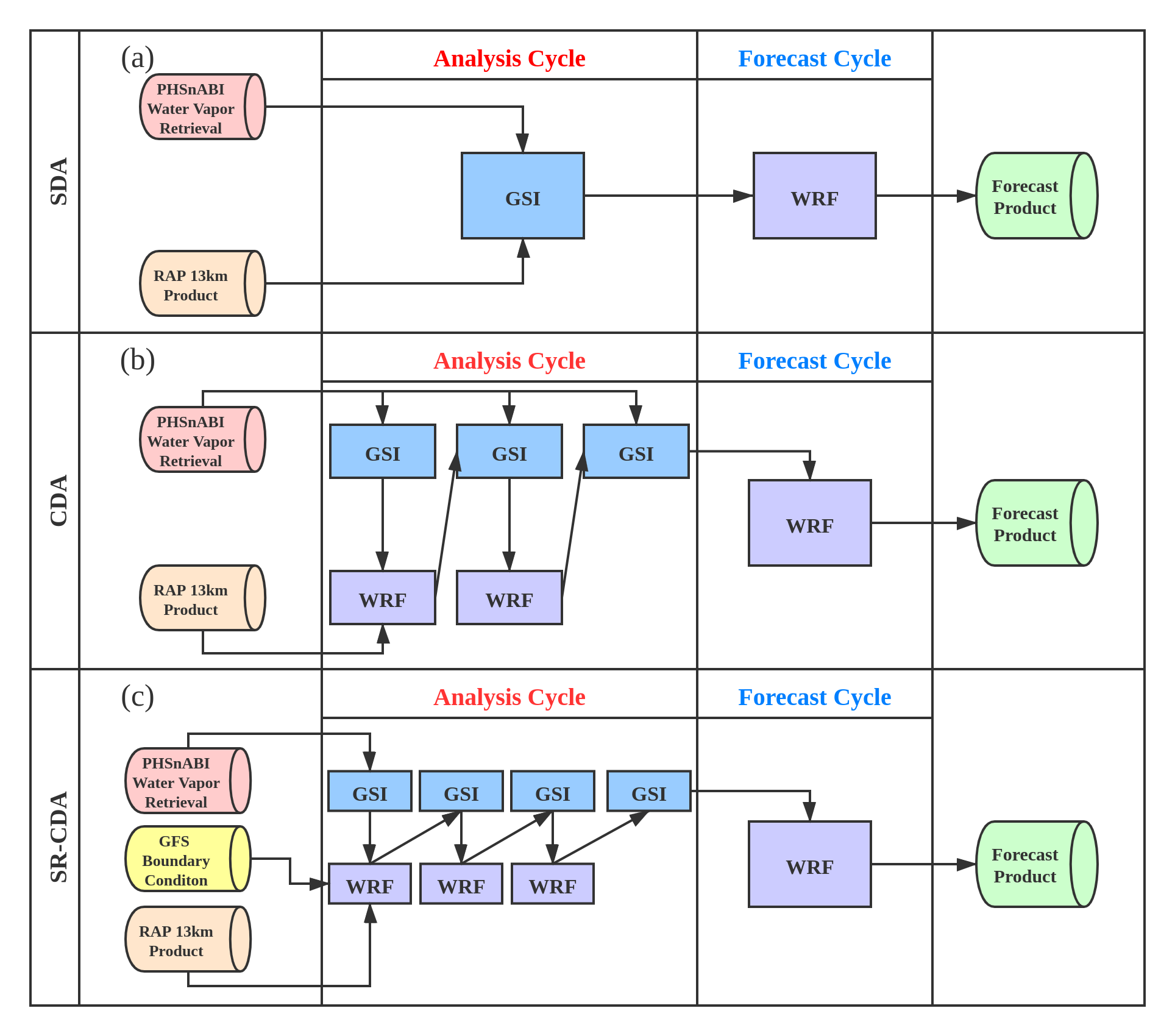
Figure 1. Schematic showing the three types of forecasts being produced from the assimilation of PHSnABI sounding data: (a) Single Data Assimilation (SDA), which provides 1-hour interval forecasts, from 1- to 12-hours, initialized on an hourly basis, (b) Continuous Data Assimilation (CDA), which provides 1-hour interval forecasts, from 1- to 12-hours, initialized on an hourly basis, and (c) Short Range Continuous Data Assimilation (SR-CDA), which provides 1-hour interval forecasts, from 1- to 72-hours, initialized on a 6-hourly basis.
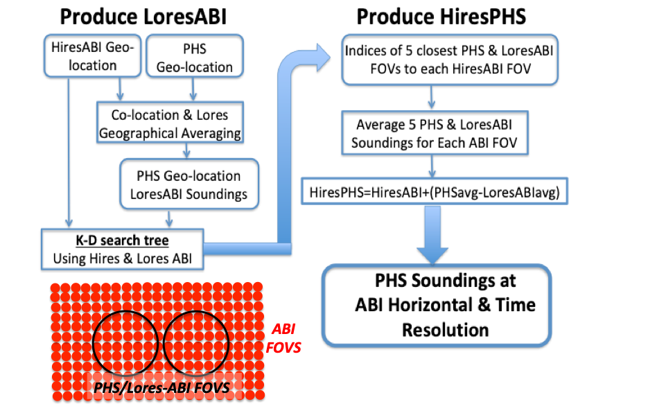
PHSnABI Retrieval
By merging Polar Hyperspectral Satellite temperature and water vapor Soundings (PHSS) generated using Dual-Regression (DR) algorithm with Advanced Baseline Imager (ABI) temperature and water vapor Soundings via Fusion technique, high spatial and temporal resolution atmospheric sounding profiles can be provided for weather forecasters to help with decision making.
References
Smith, W. L., E. Weisz, S. Kireev, D. K. Zhou, Z. Li, and E. E. Borbas, 2012: Dual-Regression Retrieval Algorithm for Real-Time Processing of Satellite Ultraspectral Radiances, J. Appl. Meteor. Clim., vol. 51, no. 8, pp.1455-1476.
Weisz, E., N. Smith, and W. L. Smith, 2015: The use of hyperspectral sounding information to monitor atmospheric tendencies leading to severe local storms. Earth and Space Science, 2, 69 –377 (2015). https://doi.org/10.1002/2015EA000122-T
Benjamin S. G., S. S. Weygandt, J. M. Brown, M. Hu, C. R. Alexander, T. G. Smirnova, et al., 2016: A North American Hourly Assimilation and Model Forecast Cycle: The Rapid Refresh. Mon. Wea. Rev., 144, 1669-1694.
Shao, H., J. Derber, X.-Y. Huang, M. Hu, K. Newman, D. Stark, M. Lueken, C. Zhou, L. Nance, Y.-H. Kuo, B. Brown, 2016: Bridging Research to Operations Transitions: Status and Plans of Community GSI. Bull. Amer. Meteor. Soc., 97, 1427-1440
Smith, W. L., and E. Weisz, 2017: Dual Regression Approach for High Spatial Resolution Infrared Soundings, in Comprehensive Remote Sensing, M. Goldberg, Editor, Elsevier Ltd, Langford Lane Oxford, OX5 1GB UK.
Weisz, E., B. Baum, and W. P. Menzel, 2017: Fusion of satellite-based imager and sounder data to construct supplementary high spatial resolution narrowband IR radiances, J. Appl. Remote Sens. 11(3), 036022 (2017) doi: 10.1117/1.JRS.11.036022.
Skamarock, W. C., J. B. Klemp, J. Dudhia, D. O. Gill, Z. Liu, J. Berner, W. Wang, J. G. Powers, M. G. Duda, D. M. Barker, and X.-Y. Huang, 2019: A Description of the Advanced Research WRF Version 4. NCAR Tech. Note NCAR/TN-556+STR, 145 pp.
Shao, M. and W. Smith, 2019: Impact of Atmospheric Retrievals on Hurricane Florence/Michael Forecasts in a Regional NWP Model, Journal of Geophysical Research – Atmospheres, 124 (15), 8544-8562.
Smith, W. L., Q. Zhang, M. Shao, and E. Weisz, 2020: Improved Severe Weather Forecasts Using LEO and GEO Satellite Soundings. J. Atmos. Oceanic Technol., doi: https://doi.org/10.1175/JTECH-D-19-0158.1.
Presentations
Smith, W. L., and E. Weisz, J. Gerth, A. DiNorscia, J. McNabb, M. Shao, M. Dutter, J. Gagan, 2019: Developing Meteorological Forecast Products in Near Real-time from Hyperspectral Sounder Radiances; American Meteorological Society 99th Annual Meeting, Phoenix AZ, 6-10 January 2019.
Zhang Q., Smith W., Shao M., Weisz E., 2020: Impact and Performance Evaluation of Combined Hyperspectral Sounder and Advanced Baseline Imager Temperature and Water Vapor Retrieval in Numerical Weather Prediction System. American Meteorological Society 100th Annual Meeting in Boston, MA.