The Planetary Boundary Layer (PBL) is commonly defined as the lowest layer in the Earth’s atmosphere directly influenced by the its surface and responding to mechanical and thermal forcing, in time scales of less than an hour. Combined, the complex diurnal, seasonal, temporal and spatial evolution of the PBL is a vital parameter for meteorological applications in air quality, convection, wind energy, hydrology, hydrometeorology, and severe weather studies. Although the PBL is a fundamental part of our meteorological studies, we remain lacking in measurements and complex dynamical understandings.
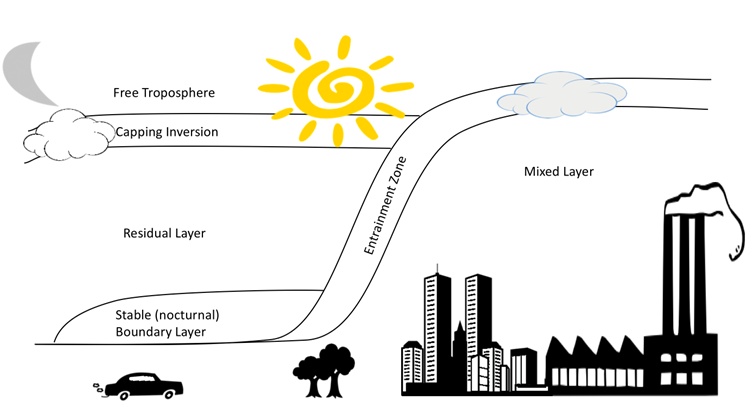
In order to define the next decade of studies to enhance our PBL understanding in both observational and computational capabilities, a structured and comprehensive plan must be established. In addition, the height of the PBL has a strong land/ocean, climatic and diurnal variation. However, despite its importance, the PBL height (PBLH cannot be directly measured but instead has to be estimated using one of several ways, ranging from measurement of turbulence, using temperature and humidity profiles or using aerosol lidar profiles, all of which can give different answers. Boundary layer meteorology and remote sensing have highlighted limitations, challenges, and benefits of PBL retrievals. Ground-based measurements can determine PBLH either through direct or indirect techniques. Further, remote sensing instrumentation can be challenged by overlap limitations between receiver and transmitters, leaving the near-surface stable layer undetected by remote sensing instrumentation. In these instances, the near-surface stable layer is neglected and therefore the validation study is only valid for relatively higher altitude residual layers, or well-developed mixing layers. This also creates increasing uncertainties in PBL measurements as reported PBL heights can be subjective to individual studies. Additionally, standard validation efforts rely on radiosonde profiles yet multiple methodologies exist to define the mixing layer, residual layer, and nocturnal stable layer using various vertical profile parameters such as virtual potential temperature, dew point temperature, wind shear/veer, or relative humidity. As various studies have shown these methods are not always in agreement and therefore introduce further uncertainties to indirect measurements validation studies. A first step in these efforts should entail a comprehensive and precise PBL definition under varying stability, synoptic, and local meteorological influences will improve validation studies and establish a strong foundation to expand our knowledge of PBL dynamics. In order to adequately represent the key boundary layer processes responsible for the exchange of energy, moisture, and pollutants between the surface and the free troposphere, high-resolution, diurnally resolved, 3D measurements of horizontal wind, temperature, humidity, and aerosol and trace gases are required.
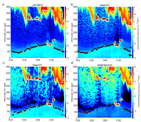
The research of the Hampton University Lidar Laboratory (HULL) relies heavily of remote sensing technology to study the impact of PBL dynamics in the fields of air quality, wind energy and meteorology. The HULL remote sensing portfolio and expertise includes elastic aerosol, Raman (water vapor), Differential Absorption Lidar (trace gases: O3 and NO2), Doppler wind lidar (wind direction and speed, and vertical velocity profiles), soundings and infrared sounders (temperature, trace gases, water vapor and relative humidity profiles) that allow for monitoring of the PBL. This also allows for the development and verification of PBL height determination algorithms using aerosol backscatter. The HULL has conducted extensive assessment of multiple algorithms (aerosol gradient method, cluster analysis, second derivative, and Haar-wavelet method) for estimating PBL height from commercial elastic aerosol lidar/ceilometer instrumentation. HULL leads the Unified Ceilometer Network, a multiagency and interdisciplinary effort to obtain planetary boundary layer heights for multiple users and needs in the scientific community as a result of the U.S. Environmental Protection Agency (EPA) redesigned Photochemical Assessment Monitoring Stations (PAMS) network that calls for boundary layer profiling and hourly mixing layer height (MLH) determinations. The primary purpose of the hourly MLH is to aid state’s State Implementation Plan (SIP) modeling data needs and support air pollution studies/monitoring during exceptional events. The MLH is an important parameter that affects near-surface concentrations serving as a diagnostic to improve air quality forecasting and dispersion models. In addition, is important in determining the relationship of atmospheric column measurements (surface and satellite) of gases and aerosol, and their surface concentrations.